|
|
|
|
|
|||
|
NEPAL | ARTICLES | KAVITAHARU | MANTHAN | COOL LINKS | GUESTBOOK | SEARCH |
|||
Map of Nepal : Jhapa District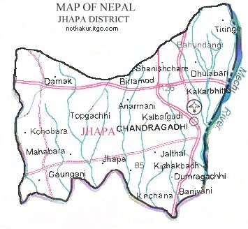
Area: 1606 sq.km Jhapa is one of the Terai districts that lies in the Eastern Development Region of Nepal. The district headquarter Bhadrapur is 13 km. south from the east west highway at Birtamode. According to the Nepal Human Development report Jhapa is in 3rd position for the overall development among the 75 districts.The major cities of Jhapa include Chandragadi, Bhadrapur, Birtamode, Damak, Dhulabari and Kakarvitta. |
|||
|
Home
| About Me
| Nepal
| Articles
| Kavitaharu
| Cool Links
Javascript | Add Email | Guestbook |
|||
