|
|
|
|
|
|||
|
NEPAL | ARTICLES | KAVITAHARU | MANTHAN | COOL LINKS | GUESTBOOK | SEARCH |
|||
Map of Nepal : Myagdi District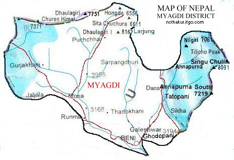
Area: 2297 sq.km Myagdi, a part of Dhaulagiri zone, is one of the seventy-five districts of Nepal. Beni is the district headquarters of Myagdi district. It consists of world's deepest gorge which divides Dhaulagiri and the Annapurna massifs. Likewise, the Kaligandaki valley is an important trekking route to Annapurna area and across the Annapurna circuit. |
|||
|
Home
| About Me
| Nepal
| Articles
| Kavitaharu
| Cool Links
Javascript | Add Email | Guestbook |
|||
