|
NEPAL
1. Overview of Nepal
2. Map & images of Nepal
- Larger Nepal map
- Map showing mountain peaks
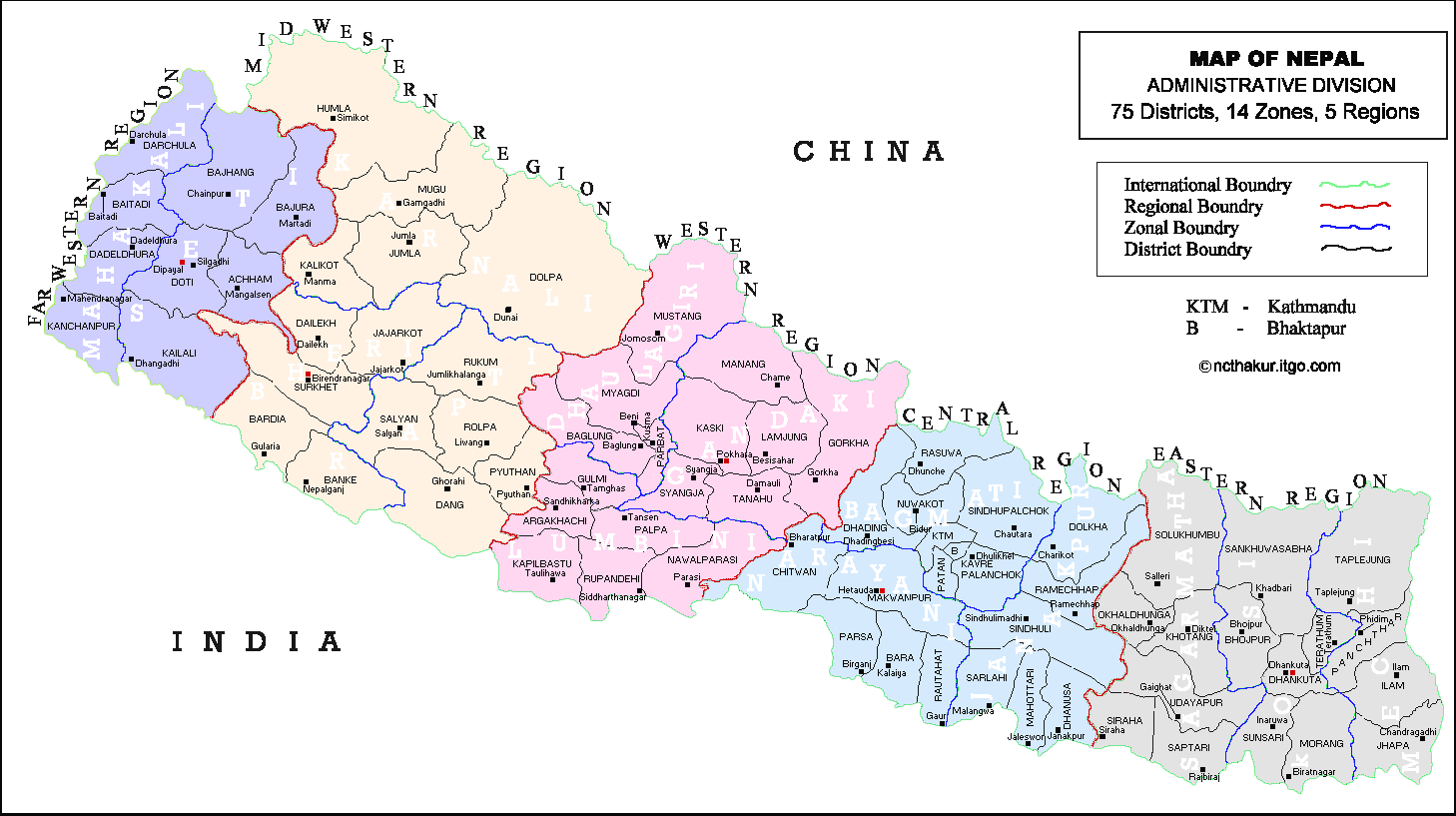
- Map showing administrative division
- Map showing Pradesh Division
- Map showing zonal division
- Map of Kathmandu Valley
- Map of Kathmandu City
- Map of Bhaktapur City
- Map of Lalitpur City
- Map of Pokhara City
3. Nepalese websites
4. Highest Mountain Peaks in Nepal
5. Panoramic View of Kathmandu Valley
6. Video Clip of a Nepali Song
7. Travel Guide to Nepal
KAVITAHARU
View few of my poems
written in Nepali language
ARTICLES
Articles on
crime prevention
investigation
& crime control
COOL LINKS
Computer
Travel & Tour
Police World
Downloads
Personality Test
Nepal News
Crime & Police News
Nepali Music
Health
Horoscope
Monthly Poll
Other
JAVASCRIPT
As I have learned as a beginner
ADD EMAIL
Search or add email to the search list.
GUESTBOOK
View to find out what other visitors have to say about this web site.
KURAKANI
Are you interested to chat? Go to Kurakani room.
FREE E-CARDS
Enormous free E-Cards of your choice. Send it to your friend and family members.
FREE SITE SUBMIT
Submit your web site to the major search engines here.
ABOUT ME
Click here to find
out about me and view few of my photographs.
|
|
Map of Nepal: Administrative Division

Map of Nepal : Administrative Divisions
Administrative
Regions & HQs of Nepal |
Area
(sq.km) |
Zones |
Administrative
Districts of Nepal |
Far-Western Region
(Dipayal - Doti) |
19,539 |
Mahakali -
Seti - |
Baitadi,
Dadeldhura, Darchula and Kanchanpur
Achham, Bajhang, Bajura, Doti and Kailali |
Mid-Western Region
(Birendranagar-Surkhet) |
42,378 |
Bheri -
Karnali -
Rapti - |
Banke, Bardia, Dailekh, Jajarkot and Surkhet
Dolpa, Humla, Jumla, Kalikot and Mugu
Dang, Pyuthan, Rolpa, Rukum and Salyan |
Western Region
(Pokhara-Kaski) |
29,398 |
Dhaulagiri -
Gandagi -
Lumbini - |
Baglung, Parbat, Mustang and Myagdi
Gorkha, Kaski, Lamjung, Manang, Syangja and Tanahu
Arghakhanchi, Gulmi, Kapilbastu, Nawalparasi, Palpa and Rupandehi |
Central Region
(Hetauda-Makwanpur) |
27,410 |
Bagmati -
Janakpur -
Narayani -
|
Bhaktapur, Dhading, Kathmandu, Kabhrepalanchok, Lalitpur(Patan), Nuwakot, Rasuwa and Sindhupalchok
Dhanusa, Dolakha, Mahottari, Ramechhap, Sarlahi, and Sindhuli
Chitawan, Bara, Makwanpur, Parsa and Rautahat |
| Eastern Region(Dhankuta) |
28,456 |
Mechi -
Sagarmatha -
Koshi - |
Ilam, Jhapa, Panchthar, and Taplejung
Khotang, Okhaldhunga, Saptari, Siraha, Solukhumbhu and Udayapur
Bhojpur, Dhankuta, Morang, Sankhuwasabha, Sunsari and Terhathum |
| NEPAL : 5 Regions |
147,181 |
14 Zones |
75 Districts |
|
|
